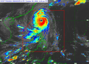
Typhoon Leon (Kong-rey) weakened from super typhoon status on Wednesday as it passed over the Orchid Islands in southern Taiwan, Philippine Atmospheric, Geophysical and Astronomical Services Administration (PAGASA) said.
In a weather advisory released by PAGASA at 11 a.m. on Thursday, the center of Typhoon Leon was estimated to be located 155 km north of Itbayat, Batanes (22.2°N, 121.9°E), moving northwestward at a speed of 25 km/h.
Leon was reported to have maximum sustained winds of 175 km/h near the center, with gusts reaching up to 215 km/h.
Although Leon may have weakened, Tropical Cyclone Wind Signals (TWCS) remain in effect across various areas in Northern Luzon.
Tropical Cyclone Wind Signal No. 3 is currently in effect for Batanes, where wind speeds of 89 to 117 km/h are expected within the next 18 hours. PAGASA warns that at this rate, the wind impact could pose a moderate to significant threat to life and property.
Tropical Cyclone Wind Signal No. 2 is in effect for the Babuyan Islands, where wind speeds of 62 to 88 km/h are expected within the next 24 hours. The wind impact could pose a minor to moderate threat to life and property.
Also, other areas, including Mainland Cagayan, Isabela, Apayao, Abra, Kalinga, Mountain Province, Ifugao, the northern portion of Benguet (Mankayan, Bakun, Buguias), Ilocos Norte, and Ilocos Sur, are under Tropical Cyclone Wind Signal No. 1, where wind speeds of 39 to 61 km/h are anticipated within the next 36 hours. The wind impact could pose a minimal to minor threat to life and property.
According to PAGASA’s track and intensity outlook, Typhoon Leon is expected to make landfall along the eastern coast of Taiwan this afternoon.
Following landfall, it will turn northeastward over the Taiwan Strait toward the East China Sea and is projected to exit the Philippine Area of Responsibility by Thursday evening or Friday morning. – Edg Adrian A. Eva

