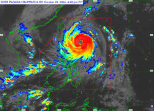
THE STATE weather bureau on Tuesday said Kong-rey, locally named Leon, has intensified into a typhoon as it moved along the east coast of Cagayan province.
In a bulletin, the Philippine Atmospheric, Geophysical and Astronomical Services Administration (PAGASA) said Kong-rey had a high likelihood of becoming a super typhoon as it passes over the Philippine Area of Responsibility.
It said the storm would be closest to Batanes province by Oct. 31. A landfall in the province was not ruled out. “Leon will likely be at or near super typhoon intensity during its closest point of approach to Batanes,” it added.
As of 5 p.m., Kong-rey was last seen 505 kilometers (km) east of Tuguegarao City or 515 km east of Aparri, Cagayan province. It was moving in a west-northwestward direction at 10 kilometers per hour (kph).
The storm was packing maximum sustained winds of 150 kph near the center and gustiness of up to 185 kph.
Due to “rapid intensification,” the weather bureau hoisted tropical wind signal No. 2 over the provinces of Batanes, Babuyan Islands, mainland Cagayan, the northern and eastern portions of Isabela, Apayao, the northern portion of Kalinga, the northern portion of Abra and Ilocos Norte.
Meanwhile, signal No. 1 was raised over the rest of Isabela, Quirino, Nueva Vizcaya, the rest of Kalinga, Mountain Province, Ifugao, Benguet, the rest of Abra, Ilocos Sur, La Union, the eastern portion of Nueva Ecija, Aurora, the northern and eastern portions of Quezon including Polillo Islands, Camarines Norte, Camarines Sur, Catanduanes, Albay and the northern portion of Sorsogon.
“The highest wind signal which may be hoisted during the occurrence of Leon is wind Signal No. 3 or 4, especially in Batanes and Babuyan Islands. The hoisting of wind Signal No. 5 is also not ruled out,” the agency added.
PAGASA also issued a gale warning over the coastal areas of Northern Luzon and the eastern seaboards of Central and Southern Luzon. — Adrian H. Halili

