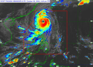
THE STATE weather bureau on Wednesday said Kong-rey, locally named Leon, has strengthened into a super typhoon as it moved closer to Batanes province in northern Philippines.
In a bulletin, the Philippine Atmospheric, Geophysical and Astronomical Services Administration (PAGASA) said Kong-rey would reach its peak intensity as it nears the northern province. It raised tropical wind signal No. 4 over the area.
“Leon will be closest to Batanes from late evening (Oct. 30) to tomorrow morning (Oct. 31). A landfall in Batanes is also not ruled out,” the agency added. Winds greater than 118 kilometers per hour (kph) to 184 kph was expected in areas under signal No. 4.
PAGASA also warned of a possible storm surge of more than three meters along the low-lying coastal communities of Batanes and Babuyan Islands. The agency placed the eastern portion of Babuyan Islands and the northeastern portion of mainland Cagayan under signal No. 3.
Areas under signal No. 2 included the rest of Babuyan Islands, the rest of mainland Cagayan, the northern portion of Isabela, Apayao, Kalinga, the northern and eastern portions of Abra, the eastern portion of Mountain Province and Ilocos Norte.
The rest of Isabela, Quirino, Nueva Vizcaya, the rest of Mountain Province, Ifugao, Benguet, the rest of Abra, Ilocos Sur, La Union, Pangasinan, Nueva Ecija, Aurora, and the northeastern portion of Tarlac were placed under signal No. 1.
As of 5 p.m., Kong-rey was last seen 215 kilometers east-southeast of Basco, Batanes, moving in a northwestward direction at 20 kph. It was packing maximum sustained winds of 185 kph near the center and gustiness of up to 230 kph.
A gale warning was also issued over the seaboard of Northern Luzon and the eastern seaboards of Central and Southern Luzon. — Adrian H. Halili

